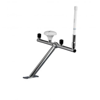
SC-70 SATELLITE COMPASS™ (GPS COMPASS)
The SC-70 is a satellite compass with a high degree of accuracy and heading of 0.4°rms. Perfect for Radar, ECDIS, AIS, Doppler Sonar and Autopilots.
SC-70 will be delivered with:
STANDARD
- Antenna Unit: SC-703 x 1
- Display unit: SC-702 x 1
- Junction Box: SC-701 x 1
- Installation materials
OPTIONAL SUPPLY
- AC/DC Power Supply Unit: PR-241
- Alarm Monitoring: IF-2503/2550
- Interface Unit: IF-NMEA SC
- Remote Display: RD-50/RD-20
- Connector (waterproof): FRU-RJ-PLUG-ASSY
- Modular Connector: MPS588-C
- LAN_CNV Kit: OP20-47/48
- Cable assembly: M12-05BFFM-010/020/060
- Connector (NMEA): LTWMC-05BFFT-SL8001
LTWMC-05BMMT-SL8001
SS-050505-FMF-TS001
FEATURES
The SC-70 has a Tri-sensor antenna, which offers great system accuracy for your ship's heading
Providing very precise heading information for the following devices: Autopilot, Radar, ARPA, Scanning Sonar, Current Indicator, Chart Plotter, ECDIS, and Autopilot.
- 0.4°rms (when using SC-70)
Ideal for small to medium-sized boats that need extremely precise heading.
Uses GNSS for high precision, such as GPS, Galileo, and GLONASS
- Eliminating the issue of not having enough satellites on hand by employing a variety of satellite.
- SBAS compatible (EGNOS,WAAS, MSAS).
- Provide exact data for SOG, COG, ROT, and L/L
For safe navigation and berthing, speed on all three axes (bow, stern, and longitudinal)
Type-approved as THD, GPS and ROTI*. Complying with following requirements (For Solas Vessels)
IMO MSC.116(73) •IMO MSC.112(73) •IMO MSC.526(13) •IMO A.694(17)
IMO MSC.97(73) •IMO MSC.191(79) •IMO MSC.302(87) •IEC 60945 Ed.4
IEC 62288 Ed.2 •IEC 61162-1 Ed. 4 •IEC 61162-2 Ed.1 •IEC 61162-450 Ed.1
IEC 61108-1 Ed.2 •ISO 22090-3 Ed.2 •ISO 20672 Ed.1
*Requires the use of the RD-50 as a display unit.
Simple integration into the shipboard network via Ethernet
The rapid follow-up rate is 45°/S
It is two times the IMO high speed craft requirement, which is 20°/s
As there are no mechanical parts, there is no need for maintenance or ongoing costs
90 second start time which is very short
Once the power is turned on, it only takes around 90 seconds for it to start. The starting time will vary somewhat depending on the equipment.
Easy to retrofit by using existing antenna cabling
- For SC-50/55/60/110/120 (The LAN_CNV option Kit is necessary)
Precision Pitch/Roll data in Analog and Digital formats for vessel stabilization, SONAR, etc.
SPECIFICATIONS
GENERAL
- Receiving frequency: 1575.42 MHz (GPS/Galileo), 1602.5625 MHz (GLONASS)
- Tracking code: C/A code (GPS), E1B (Galileo), 1OF (GLONASS)
- Positional accuracy (dependent on ionospheric activity and multipath):GPS 5 m approx. (2drms, HDOP<4) / DGPS 4 m approx. (2drms, HDOP<4) / WAAS 3 m approx. (2drms, HDOP<4) / MSAS 4 m approx. (2drms, HDOP<4)
- Ship’s speed accuracy (SOG): 0.02 kn rms (tracking satellites 5 or more)
- Ship’s speed accuracy (VBW, SOG)S: 0.2% of ship’s speed or 0.02 kn whichever is the greater (tracking satellites 5 or more, at antenna unit)
- Course accuracy: SC-70 0.4° rms, SC-130 0.25° rms
- Course resolution: 0.1°,0.01°,0.001° (select from menu)
- Tracking bearing: 45°/s
- Position fixing time: 90 s approx. (typical)
- Attitude accuracy: Pitch/ Roll: 0.4° rms
- Attitude resolution: 0.1°,0.01°,0.001° (select from menu)
- Rate of turn: 0.1° ,0.01, 0.001°/min (select from menu)
- Heave accuracy: 5 cm (1σ)
DISPLAY UNIT
- Screen: 4.3-inch color LCD, 95.04 mm (W) x 87.12 mm (H)
- Resolution: 480 x 272 dots (WQVGA)
- Brilliance: 600 cd/m2 typical
- Contrast: 17 levels
- Display mode: Heading, Nav data, Rate of turn and Speed modes (Non-IMO mode only)
- Visible distance: 0.65 m nominal
INTERFACE (JUNCTION BOX)
Number of ports (junction box)
- IEC61162-2: 1 port (IN: 1, OUT: 1)
- IEC61162-1: 8 ports (IN: 4, OUT: 8)
- External beacon input (DATA5 port): RTCM SC-104 V2.3 (RS-485), ITU-R M823
- NMEA2000: 1 port
- AD-10: 4 ports, for heading output
- RS-485: 1 port, for display unit connection
- LAN (IEC61162-450): 2 ports, Ethernet, 100Base-TX, RJ45 connecter,
IGMPv2 acceptable
Data sentences
- Serial data: Input: ACK, ACM, ACN, HBT, HDT*1, MSK, MSS, THS, VBW*2, VDR*2
Output: ALC, ALF, ALR, ARC, DTM, GBS, GGA, GLL, GNS, GRS, GSA, GST, GSV, HBT, HDG*2, HDM*2, HDT*1, HRM*2, MSK, POS, RMC, ROT, THS,VBW*2, VDR*2, VHW*2, VLW*2, VTG, XDR*2, ZDA
-
Ethernet data: Input: ACK, ACM, ACN, HBT, SRP
Output: ALC, ALF, ALR, ARC, DTM, GBS, GGA, GLL, GNS, GRS, GSA, GST, GSV, HBT, HDG*2, HDM*2, HDT*1, HRM*2, POS, RMC, ROT, SRP, THS, VBW*2, VDR*2, VHW*2, VLW*2, VTG, XDR*2, ZDA
Output proprietary sentences: PFEC GPatt, GPhve, GPimu, pidat, pireq
PGN
- Input: 059392/904, 060928, 061184, 126208/720/996
- Output: 059392/904, 060928, 061184, 065280, 126208/464/720/992/996,127250/251/252/257/258, 129025/026/029/033/044/291/539/540/545/547, 130310/312/314/316/577/578/822/823/842/843/845/846
IEC61162-450 transmission group
- Input: MISC, SATD, NAVD, NETA, PROP
- Output: Arbitrary (default: SATD)
Other network function: NTP, HTTP, excepted IEC61162-450
*1: Not used for SOLAS vessels.
*2: for Non-IMO types only.
POWER SUPPLY
- Junction box: 12-24 VDC: 2.1-1.1 A (included antenna unit and display unit)
- Rectifier (PR-240, option): 100-115/220-230 VAC, 1 phase, 50-60 Hz and 24 VDC
ENVIRONMENTAL CONDITIONS
- Ambient temperature: Antenna unit -25°C to +55°C (storage: +70°C)
Display unit/ Junction box -15°C to +55°C
- Relative humidity: 95% or less at +40°C
- Degree of protection: Antenna unit IP56
Display unit IP22 (IP35: option)
Junction box IP20 (IP22: bulkhead mount)
- Vibration: IEC 60945 Ed.4
For : Recreational Boats
Fishing Vessels
Work Boats
BROCHURES


